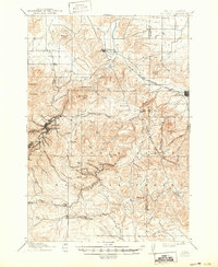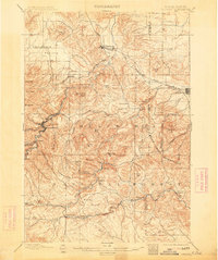
1899 Map of Sturgis
USGS Topo · Published 1913About this map
The northern reaches of the Black Hills define this landscape during a period of significant growth for the mining and military sectors of western South Dakota. At the center of the region's transport network, the Fremont Elkhorn and Missouri Valley railroad snakes through the hills, connecting key mining hubs like Deadwood and Whitewood to the plains. The presence of the Fort Meade Military Reservation adjacent to Sturgis highlights the area's strategic importance during the late nineteenth century. Beyond the major hubs, the map details smaller mining and logging outposts such as Galena, Virginia, and Runkel tucked into the gulches of the Black Hills National Forest. Settlers utilized more level terrain at Centennial Prairie and Boulder Park, while landmarks like Elkhorn Peak and White Rock provided navigation points for travelers navigating the complex network of creeks including Whitewood Creek and Elk Creek.
Find a feature on this map
52 named features on this map. Tap any name to fly to it.
Don’t see what you’re looking for? This feature index may not catch every label — zoom into the map to look around manually.
Map Details
Editions of this 1899 Sturgis Map
2 editions found

Historical Maps of Spearfish Through Time
7 maps found