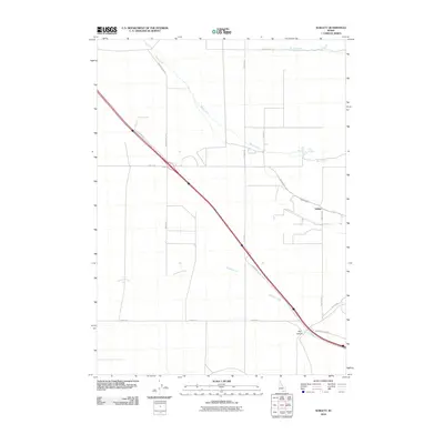
2010 Map of Sublett
USGS Topo · Published 2010About this map
The high desert landscape of Cassia County is defined by the intersection of remote rural roads and life-giving water sources. Sublett remains the primary point of orientation, situated where Sublett Rd meets 3350 East Rd near the drainage of Sublett Creek. The geography is shaped by the descent of water from the surrounding highlands, notably through Big Canyon and along the seasonal paths of Meadow Creek and Warm Creek. A curious local landmark, Hot Springs, appears to the northeast, signaling the geothermal activity common to this region of Idaho. The map reveals a sparse but deliberate network of transit, including Juniper Rd and Harris Rd, which serve the high basin's agricultural and ranching interests during the early 21st century. This survey documents the area's enduring reliance on creek-fed valleys for settlement in a landscape otherwise dominated by expansive open terrain.
Find a feature on this map
20 named features on this map. Tap any name to fly to it.
Don’t see what you’re looking for? This feature index may not catch every label — zoom into the map to look around manually.
Map Details
Editions of this 2010 Sublett Map
This is the sole edition of this map. No revisions or reprints were ever made.
Other maps of this area

1954 · Pocatello
USGS Topo · 1:250,000

1958 · Pocatello
USGS Topo · 1:250,000

1958 · Sublett
USGS Topo · 1:62,500

1959 · Strevell
USGS Topo · 1:62,500

1968 · Malta NE
USGS Topo · 1:24,000

1968 · Malta
USGS Topo · 1:24,000

1968 · Bridge
USGS Topo · 1:24,000
1985 · North Heglar Canyon
USGS Topo · 1:24,000
1985 · Sandrock Canyon
USGS Topo · 1:24,000
1985 · Sublett
USGS Topo · 1:24,000