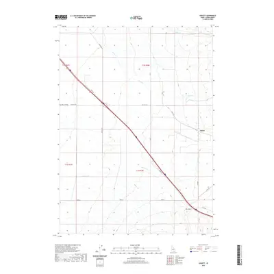
2020 Map of Sublett
USGS Topo · Published 2020About this map
The Raft River Valley landscape dominates this modern survey of Cassia County, where a network of seasonal and perennial waterways defines the high-desert terrain. The small community of Sublett sits at the eastern edge of the quadrangle, serving as a landmark in a region characterized by wide basins and deep incisions like Big Canyon. The drainage pattern is complex, with Sublett Cr and Meadow Cr flowing toward the valley floor, while the presence of Hot Springs near the northern boundary suggests the geothermal activity common to this part of southern Idaho.
Find a feature on this map
21 named features on this map. Tap any name to fly to it.
Don’t see what you’re looking for? This feature index may not catch every label — zoom into the map to look around manually.
Map Details
Editions of this 2020 Sublett Map
This is the sole edition of this map. No revisions or reprints were ever made.
Other maps of this area

1954 · Pocatello
USGS Topo · 1:250,000

1958 · Pocatello
USGS Topo · 1:250,000

1958 · Sublett
USGS Topo · 1:62,500

1959 · Strevell
USGS Topo · 1:62,500

1968 · Malta NE
USGS Topo · 1:24,000

1968 · Malta
USGS Topo · 1:24,000

1968 · Bridge
USGS Topo · 1:24,000
1985 · North Heglar Canyon
USGS Topo · 1:24,000
1985 · Sandrock Canyon
USGS Topo · 1:24,000
1985 · Sublett
USGS Topo · 1:24,000