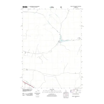
2011 Map of Sublett Reservoir
USGS Topo · Published 2011About this map
Sublett Reservoir serves as the central focal point of this Cassia County landscape, where the waters of Lake Fork and Sublett Creek are managed by the Sublett Dam. The map reveals a high-altitude network of drainage and water sources, including the South Fork Fall Creek Spring and Pine Creek Spring, which are critical for supporting life in this arid canyon environment. The human footprint is sparse but significant, defined by ranching and recreational infrastructure like the Broken Circle Ranch and the Sublett Reservoir Access Area. Rugged geography is named throughout, with Beaver Dam Canyon, Cold Spring Canyon, and Hutchey Canyon cutting through the terrain. A simple road system, including Sublett Rd and Meadow Creek Rd, provides the only conduits through these remote Idaho watersheds.
Find a feature on this map
21 named features on this map. Tap any name to fly to it.
Don’t see what you’re looking for? This feature index may not catch every label — zoom into the map to look around manually.
Map Details
Editions of this 2011 Sublett Reservoir Map
This is the sole edition of this map. No revisions or reprints were ever made.
Other maps of this area

1954 · Pocatello
USGS Topo · 1:250,000

1958 · Pocatello
USGS Topo · 1:250,000

1958 · Sublett
USGS Topo · 1:62,500

1959 · Strevell
USGS Topo · 1:62,500

1973 · Juniper
USGS Topo · 1:24,000

1973 · Hartley Peak
USGS Topo · 1:24,000

1973 · Sublett Troughs
USGS Topo · 1:24,000
1984 · Malad City
USGS Topo · 1:100,000
1985 · North Heglar Canyon
USGS Topo · 1:24,000
1985 · Sandrock Canyon
USGS Topo · 1:24,000