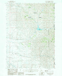
1985 Map of Sublett Reservoir
USGS Topo · Published 1985About this map
Sublett Reservoir serves as a focal point within the high-elevation basin of the Sublett Range during the mid-1980s. This drainage network, situated largely within the Sawtooth National Forest, is defined by a series of springs and seasonal watercourses such as South Fork Fall Creek Spring and Pine Grove Spring. The map documents the complex intersection of the Cassia, Power, and Oneida county lines, tracing the course of Sublett Creek as it flows toward the reservoir's spillway. The landscape is characterized by steep drainages like Cold Spring Canyon and Hutchey Canyon, illustrating the hydrological importance of the region's upland springs and creeks, including Beaver Dam Creek and Meadow Creek, in supporting the local watershed and reservoir system.
Find a feature on this map
16 named features on this map. Tap any name to fly to it.
Don’t see what you’re looking for? This feature index may not catch every label — zoom into the map to look around manually.
Map Details
Editions of this 1985 Sublett Reservoir Map
This is the sole edition of this map. No revisions or reprints were ever made.
Other maps of this area

1954 · Pocatello
USGS Topo · 1:250,000

1958 · Pocatello
USGS Topo · 1:250,000

1958 · Sublett
USGS Topo · 1:62,500

1959 · Strevell
USGS Topo · 1:62,500

1973 · Juniper
USGS Topo · 1:24,000

1973 · Hartley Peak
USGS Topo · 1:24,000

1973 · Sublett Troughs
USGS Topo · 1:24,000
1984 · Malad City
USGS Topo · 1:100,000
1985 · North Heglar Canyon
USGS Topo · 1:24,000
1985 · Sandrock Canyon
USGS Topo · 1:24,000