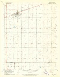
1968 Map of Sublette
USGS Topo · Published 1970About this map
The high plains of Haskell and Lockport townships center on the town of Sublette, the county seat. This late-1960s landscape is defined by the extraction economy and the logistics of the Southern Plains, characterized by a vast network of Gas Wells and an extensive Pipeline system that crisscrosses the terrain. The Atchison Topeka and Santa Fe railroad line runs directly through the heart of the settlement, reinforcing the community's role as a transportation and agricultural hub. In the town itself, local life is anchored by the High Sch and communication infrastructure like the Radio Tower, while the Sublette Flying Club Landing Strip to the north reflects the region's reliance on aviation for distance travel across the Kansas prairie. The transition into Morris township and across the southern border into Seward County shows the continuation of this industrial and agricultural pattern.
Find a feature on this map
12 named features on this map. Tap any name to fly to it.
Don’t see what you’re looking for? This feature index may not catch every label — zoom into the map to look around manually.
Map Details
Editions of this 1968 Sublette Map
2 editions found
Other maps of this area

1896 · Garden
USGS Topo · 1:125,000

1955 · Dodge City
USGS Topo · 1:250,000

1958 · Dodge City
USGS Topo · 1:250,000

1959 · Dodge City
USGS Topo · 1:250,000

1960 · Garden City 3 SW
USGS Topo · 1:24,000

1960 · Garden City 3 SE
USGS Topo · 1:24,000

1968 · Plains SW
USGS Topo · 1:24,000

1968 · Sublette SW
USGS Topo · 1:24,000

1968 · Plains NW
USGS Topo · 1:24,000
1968 · Satanta
USGS Topo · 1:24,000