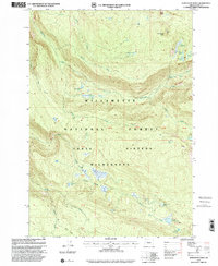
1997 Map of Substitute Point
USGS Topo · Published 2001About this map
The Three Sisters Wilderness dominates this high-altitude landscape within the Willamette National Forest, characterized by its dense network of glacial and alpine water features. The terrain is defined by dramatic elevations such as Substitute Point and Proxy Point, which overlook a complex drainage system including Separation Creek, Horse Creek, and Honey Creek. Local history and land use are evidenced by Ingram Camp, a small settlement node amidst the vast protected timberland.
Find a feature on this map
35 named features on this map. Tap any name to fly to it.
Don’t see what you’re looking for? This feature index may not catch every label — zoom into the map to look around manually.
Map Details
Editions of this 1997 Substitute Point Map
This is the sole edition of this map. No revisions or reprints were ever made.
Other maps of this area

1925 · Waldo Lake
USGS Topo · 1:125,000

1929 · Three Sisters
USGS Topo · 1:125,000

1930 · Maiden Peak
USGS Topo · 1:125,000

1932 · Three Sisters
USGS Topo · 1:125,000

1934 · Maiden Peak
USGS Topo · 1:125,000

1934 · Mc Kenzie Bridge
USGS Topo · 1:96,000

1940 · Mc Kenzie Bridge
USGS Topo · 1:125,000

1953 · Salem
USGS Topo · 1:250,000

1954 · Salem
USGS Topo · 1:250,000

1955 · Chucksney Mtn
USGS Topo · 1:62,500