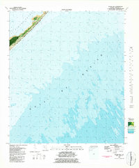
1981 Map of Sugar Hill
USGS Topo · Published 1982About this map
St George Island State Park dominates the slender northern tip of St George Island, a barrier landmass separating the open Gulf of Mexico from the protected waters of St George Sound. This 1981 orthophotomap provides a hybrid view of the landscape, combining topographic contours with photographic imagery to reveal the complex system of sand bars and underwater shoals extending from the coastline. Marsh Island and Pilot Harbor mark the landward side of the spit, where the transition from stable ground to shifting maritime environment is most evident. The bathymetric data, compiled from tide-coordinated surveys, highlights the shallow, ever-changing nature of the sound's floor and the vulnerable positioning of this coastal barrier during the early 1980s.
Find a feature on this map
6 named features on this map. Tap any name to fly to it.
Don’t see what you’re looking for? This feature index may not catch every label — zoom into the map to look around manually.
Map Details
Editions of this 1981 Sugar Hill Map
This is the sole edition of this map. No revisions or reprints were ever made.
Other maps of this area

1943 · Dog Island
USGS Topo · 1:31,680

1943 · Carrabelle
USGS Topo · 1:24,000

1944 · Carrabelle
USGS Topo · 1:31,680

1944 · Green Point
USGS Topo · 1:31,680

1944 · Sugar Hill
USGS Topo · 1:31,680

1945 · Sugar Hill
USGS Topo · 1:31,680

1949 · Apalachicola
USGS Topo · 1:250,000

1950 · Goose Island
USGS Topo · 1:31,680

1957 · Apalachicola
USGS Topo · 1:250,000

1959 · Apalachicola
USGS Topo · 1:250,000