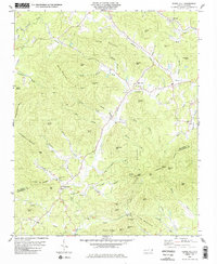
1985 Map of Sugar Hill
USGS Topo · Published 1986About this map
Sugar Hill serves as a central landmark in this mid-1980s topography of the Blue Ridge foothills, situated near the headwaters of the Second Broad River. The landscape is defined by its complex drainage systems, including Cove Creek and Morgan Creek, which carve through a series of named ridges and peaks like Ledbetter Ridge and Harris Mountain. This survey illustrates the rural community structure of the era, where small settlements like Whitehouse are anchored by local institutions such as the Montford Cove Ch.
Find a feature on this map
68 named features on this map. Tap any name to fly to it.
Don’t see what you’re looking for? This feature index may not catch every label — zoom into the map to look around manually.
Map Details
Editions of this 1985 Sugar Hill Map
This is the sole edition of this map. No revisions or reprints were ever made.
Other maps of this area

1900 · Mount Mitchell
USGS Topo · 1:125,000

1902 · Mount Mitchell
USGS Topo · 1:125,000

1905 · Morganton
USGS Topo · 1:125,000

1907 · Saluda
USGS Topo · 1:125,000

1934 · Parts Of Old Fort and Montreat
USGS Topo · 1:24,000

1953 · Charlotte
USGS Topo · 1:250,000

1954 · Charlotte
USGS Topo · 1:250,000

1955 · Knoxville
USGS Topo · 1:250,000

1957 · Knoxville
USGS Topo · 1:250,000

1959 · Lake Lure
USGS Topo · 1:62,500