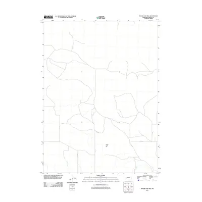
2011 Map of Sugar Loaf Hill
USGS Topo · Published 2011About this map
Sugar Loaf Hill rises above the open range of Garden County, serving as a prominent landmark in this sparsely settled portion of the Nebraska Sandhills. This 2011 survey documents a landscape defined by an organized grid of section roads and grazing lands, where water is the primary driver of life and geography. The drainage of Mutton Creek and Lost Creek provides the essential hydrology for the region, cutting through the terrain and dictating the placement of the sparse network of rural roads. The area is connected by a series of numbered routes including Road 76, Road 74, and the appropriately named Trail Rd, which likely traces older paths through the prairie. This map offers a clear look at the contemporary infrastructure of the high plains, where the vastness of the land is measured by these intermittent creek beds and lonely ranch roads.
Find a feature on this map
11 named features on this map. Tap any name to fly to it.
Don’t see what you’re looking for? This feature index may not catch every label — zoom into the map to look around manually.
Map Details
Editions of this 2011 Sugar Loaf Hill Map
This is the sole edition of this map. No revisions or reprints were ever made.
Other maps of this area

1896 · Browns Creek
USGS Topo · 1:125,000

1899 · Browns Creek
USGS Topo · 1:125,000

1899 · Sidney
USGS Topo · 1:125,000

1900 · Chappell
USGS Topo · 1:125,000

1950 · Crescent Lake
USGS Topo · 1:62,500

1954 · Scottsbluff
USGS Topo · 1:250,000

1958 · Scottsbluff
USGS Topo · 1:250,000

1971 · Richardson Lake
USGS Topo · 1:24,000

1971 · Coumbe Bluff
USGS Topo · 1:24,000
1971 · Buske Ranch
USGS Topo · 1:24,000