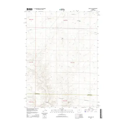
2015 Map of Sugar Loaf
USGS Topo · Published 2015About this map
The California-Oregon Trl cuts across this high desert landscape, marking the enduring path of one of America's most significant historical migration routes. This 2015 survey shows the trail passing just south of the distinctive Sugar Loaf landform, which served as a prominent landmark for travelers and surveyors alike. The terrain is defined by its drainage patterns, most notably West Buckhorn Draw and East Buckhorn Draw, which converge near the boundary shared by the Sublette and Sweetwater County line. Modern infrastructure is represented by Yellow Point Rd and Blm-4205, providing access through this vast public land managed under the Public Land Survey System. The map documents the persistent layout of these high-altitude ranges within townships like t27n r109w and t26n r110w at the start of the 21st century.
Find a feature on this map
13 named features on this map. Tap any name to fly to it.
Don’t see what you’re looking for? This feature index may not catch every label — zoom into the map to look around manually.
Map Details
Editions of this 2015 Sugar Loaf Map
This is the sole edition of this map. No revisions or reprints were ever made.
Other maps of this area

1955 · Lander
USGS Topo · 1:250,000

1958 · Lander
USGS Topo · 1:250,000

1961 · Lander
USGS Topo · 1:250,000

1968 · Twelvemile Knoll
USGS Topo · 1:24,000
1968 · Monument Butte NE
USGS Topo · 1:24,000
1968 · Monument Butte
USGS Topo · 1:24,000

1969 · Oasis Well
USGS Topo · 1:24,000
1969 · Sugar Loaf
USGS Topo · 1:24,000
1969 · Teakettle Butte
USGS Topo · 1:24,000
1969 · Sugar Loaf NW
USGS Topo · 1:24,000