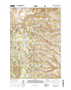
2014 Map of Sugarbowl Creek
USGS Topo · Published 2014About this map
Umatilla National Forest dominates this section of the Blue Mountains, where a complex network of forest development roads provides access to isolated drainages and summits. The landscape is defined by the high prominence of Battle Mtn and the unique topographic depression known as The Big Pot. Multiple water sources, including Gulliford Spring, Log Spring, and Sturdevant Spring, indicate a terrain where water management and access were critical for both forestry and early grazing. The drainage systems of Sugarbowl Creek and Deerlick Cr carve deep into the plateau, separated by the elevated spine of Sugarbowl Ridge. This 2014 survey reveals the intensive management of public lands, as evidenced by the high density of National Forest Development roads, such as Nat For Dev RD 053 and Nat For Dev RD 010, which crisscross the rugged township boundaries.
Find a feature on this map
61 named features on this map. Tap any name to fly to it.
Don’t see what you’re looking for? This feature index may not catch every label — zoom into the map to look around manually.
Map Details
Editions of this 2014 Sugarbowl Creek Map
This is the sole edition of this map. No revisions or reprints were ever made.
Other maps of this area

1953 · Pendleton
USGS Topo · 1:250,000

1956 · Pendleton
USGS Topo · 1:250,000

1967 · Bridge Creek
USGS Topo · 1:24,000

1967 · Carney Butte
USGS Topo · 1:24,000

1967 · Ukiah
USGS Topo · 1:24,000

1968 · Hoodlum Canyon
USGS Topo · 1:24,000

1968 · Gurdane
USGS Topo · 1:24,000

1969 · Sugarbowl Creek
USGS Topo · 1:24,000

1969 · Deerhorn Creek
USGS Topo · 1:24,000

1969 · Thompson Flat
USGS Topo · 1:24,000