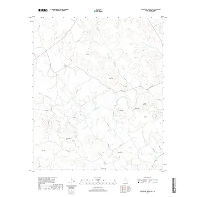
2019 Map of Sugarloaf Mountain
USGS Topo · Published 2019About this map
Sugarloaf Mountain and Norse Hill anchor the terrain of this Bosque County landscape, characterized by a series of prominent peaks and limestone-capped ridges. The hydrological network is dominated by the westward-flowing Meridian Creek, which gathers waters from Spring Creek, Gin Br, and several other intermittent drainages before they meet the North Bosque River in the northeastern corner. Rural infrastructure is defined by a dense grid of county roads and farm-to-market routes like Farm Rd 2136, which serve remote homesteads and ranching properties.
Find a feature on this map
47 named features on this map. Tap any name to fly to it.
Don’t see what you’re looking for? This feature index may not catch every label — zoom into the map to look around manually.
Map Details
Editions of this 2019 Sugarloaf Mountain Map
This is the sole edition of this map. No revisions or reprints were ever made.
Other maps of this area

1888 · Meridian
USGS Topo · 1:125,000

1894 · Meridian
USGS Topo · 1:125,000

1954 · Waco
USGS Topo · 1:250,000

1955 · Waco
USGS Topo · 1:250,000

1955 · Clifton
USGS Topo · 1:24,000

1955 · Meridian
USGS Topo · 1:24,000
1955 · Pilot Knob
USGS Topo · 1:24,000
1956 · Hurst Spring
USGS Topo · 1:24,000

1956 · Cranfills Gap
USGS Topo · 1:24,000
1956 · Mosheim
USGS Topo · 1:24,000