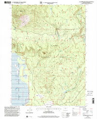
1999 Map of Sugarpine Mountain
USGS Topo · Published 2002About this map
Sugarpine Mountain dominates the northwestern corner of this landscape, its summit marked by Lookout BM 6398. This high timberland within the Winema National Forest transitions sharply in the west to the low, saturated grounds of the Klamath Marsh National Wildlife Refuge. The map reveals a history of forest management and fire, indicated by several named areas of regrowth like Bedpan Burn and Junction Burn.
Find a feature on this map
25 named features on this map. Tap any name to fly to it.
Don’t see what you’re looking for? This feature index may not catch every label — zoom into the map to look around manually.
Map Details
Editions of this 1999 Sugarpine Mountain Map
This is the sole edition of this map. No revisions or reprints were ever made.
Other maps of this area

1889 · Klamath
USGS Topo · 1:250,000

1894 · Klamath
USGS Topo · 1:250,000

1935 · Chemult
USGS Topo · 1:96,000

1941 · Chemult
USGS Topo · 1:125,000

1955 · Crescent
USGS Topo · 1:250,000

1955 · Klamath Falls
USGS Topo · 1:250,000

1957 · Crescent
USGS Topo · 1:250,000

1957 · Klamath Marsh
USGS Topo · 1:62,500

1958 · Crescent
USGS Topo · 1:250,000

1958 · Klamath Falls
USGS Topo · 1:250,000