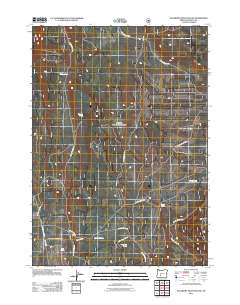
2011 Map of Sugarpine Mountain NW
USGS Topo · Published 2011About this map
Lost Creek Spring and numerous other water sources define this high-altitude landscape in the southern Oregon Cascades. The map reveals an intricate network of National Forest roads, including Nat For Dev Rd 9415 and Nat For Dev Rd 8604, which provide access to the area's timber and water resources. The concentration of named springs, such as Grimmet Spring and Bootleg Spring, suggests a vital hydrologic system essential for the region's forest management and wildlife. Shoestring Creek flows through the southern portion of the quadrangle, joined by the waters of Shoestring Spring. This survey captures the specialized infrastructure of a working forest, where the grid of development roads intersects with the natural drainage patterns of Lost Creek and the surrounding volcanic terrain.
Find a feature on this map
20 named features on this map. Tap any name to fly to it.
Don’t see what you’re looking for? This feature index may not catch every label — zoom into the map to look around manually.
Map Details
Editions of this 2011 Sugarpine Mountain NW Map
This is the sole edition of this map. No revisions or reprints were ever made.
Other maps of this area

1935 · Chemult
USGS Topo · 1:96,000

1941 · Chemult
USGS Topo · 1:125,000

1955 · Crescent
USGS Topo · 1:250,000

1957 · Crescent
USGS Topo · 1:250,000

1958 · Crescent
USGS Topo · 1:250,000
1967 · Chemult
USGS Topo · 1:24,000
1967 · Muttonchop Butte
USGS Topo · 1:24,000
1967 · Mazama
USGS Topo · 1:24,000
1967 · Walker Mtn
USGS Topo · 1:24,000
1967 · Sellers Marsh
USGS Topo · 1:24,000