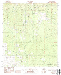
1986 Map of Sugrue
USGS Topo · Published 1986About this map
Kisatchie National Forest dominates the landscape of this mid-1980s survey, where the piney woods are intersected by a dense network of creek branches and drainage systems. The small settlements of Cravens and Sugrue appear as localized hubs within the forest boundary, while Cole Central and Denard mark the southern and eastern edges of the quadrangle. The topography is defined by the winding course of Whisky Chitto Creek and Little Sixmile Creek, which are fed by numerous small tributaries like Sassafras Branch and Marlow Branch. This period of the 1980s reveals a region balancing timber resources with light industrial activity, evidenced by the presence of a Gravel Pit and several Cem locations that provide important clues for genealogists tracking family plots in rural Vernon Parish. The border between Vernon Parish and Beauregard Parish runs along the southern boundary, anchoring the map's location in southwest Louisiana.
Find a feature on this map
33 named features on this map. Tap any name to fly to it.
Don’t see what you’re looking for? This feature index may not catch every label — zoom into the map to look around manually.
Map Details
Editions of this 1986 Sugrue Map
2 editions found
Other maps of this area

1941 · Slagle
USGS Topo · 1:62,500

1943 · Leander
USGS Topo · 1:62,500

1944 · Slagle
USGS Topo · 1:62,500

1947 · Ikes
USGS Topo · 1:31,680

1947 · Chasmore
USGS Topo · 1:31,680

1947 · Grant
USGS Topo · 1:31,680

1947 · Sugartown
USGS Topo · 1:31,680

1947 · Sugrue
USGS Topo · 1:31,680

1947 · Pitkin
USGS Topo · 1:31,680

1948 · Grant
USGS Topo · 1:24,000