
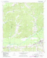
1967 Map of Sulligent
USGS Topo · Published 1968About this map
The Buttahatchee River meanders across the state line in the late 1960s, anchoring a landscape defined by the St Louis - San Francisco railroad and the town of Sulligent. This survey reveals the rural character of the Alabama-Mississippi border, where small settlements like Gattman and Pine Springs are connected by a network of creeks, including Indian Creek and Turkey Bogue. The map is particularly valuable for its density of community landmarks, recording numerous family cemeteries such as Almon Cem and Sandlin Cem, alongside local congregations at Macedonia Ch and Wesley Chapel. The presence of multiple Gravel Pits along the riverbanks and the Gaging Station near the railway crossing point to the local extraction industry and water management practices of the era.
Find a feature on this map
36 named features on this map. Tap any name to fly to it.
Don’t see what you’re looking for? This feature index may not catch every label — zoom into the map to look around manually.
Map Details
Editions of this 1967 Sulligent Map
2 editions found
Other maps of this area

1953 · West Point
USGS Topo · 1:250,000

1956 · Tupelo
USGS Topo · 1:250,000

1958 · Tupelo
USGS Topo · 1:250,000

1958 · West Point
USGS Topo · 1:250,000

1963 · West Point
USGS Topo · 1:250,000

1966 · Turon
USGS Topo · 1:24,000

1966 · Greenwood Springs
USGS Topo · 1:24,000

1966 · Amory SE
USGS Topo · 1:24,000

1967 · Beaverton
USGS Topo · 1:24,000
1967 · Henson Springs
USGS Topo · 1:24,000