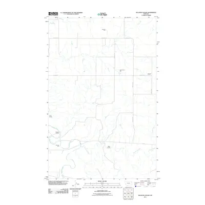
2011 Map of Sullivan Coulee
USGS Topo · Published 2011About this map
Redwater River and its tributary, the East Redwater River, dominate the drainage patterns of this McCone County landscape. The map reveals a highly specialized agricultural and water-management system defined by several small-scale impoundments, including Newman Dam, Win Number 1 Dam, and Willough Dam. These features illustrate how regional water resources are captured in an area characterized by deep erosional cuts like Sullivan Coulee and Alkali Coulee. Local history is anchored at the Grandview Cemetery, which sits along the intersection of County Rd 142 and County Rd 144. This network of rural roads, including Sunnyside Rd and Doornek Rd, connects isolated properties and water sites across the open plains of eastern Montana.
Find a feature on this map
18 named features on this map. Tap any name to fly to it.
Don’t see what you’re looking for? This feature index may not catch every label — zoom into the map to look around manually.
Map Details
Editions of this 2011 Sullivan Coulee Map
This is the sole edition of this map. No revisions or reprints were ever made.
Other maps of this area

1912 · Chelsea
USGS Topo · 1:62,500

1912 · Poplar
USGS Topo · 1:62,500

1954 · Glendive
USGS Topo · 1:250,000

1954 · Wolf Point
USGS Topo · 1:250,000

1957 · Glendive
USGS Topo · 1:250,000

1958 · Wolf Point
USGS Topo · 1:250,000

1958 · Glendive
USGS Topo · 1:250,000

1972 · Poplar
USGS Topo · 1:24,000
1972 · Nickwall
USGS Topo · 1:24,000
1972 · Sprole
USGS Topo · 1:24,000