
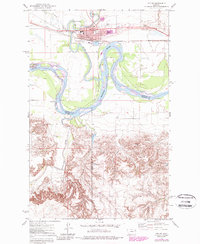
1972 Map of Poplar
USGS Topo · Published 1975About this map
Poplar serves as the focal point of this 1970s survey, situated along the Burlington Northern line and the Poplar River within the Fort Peck Indian Reservation. The town is characterized by its agricultural and transportation infrastructure, featuring several Grain Elevators, the Poplar Airport, and a Drive-in Theater on the eastern edge. The confluence of the Poplar River and the Missouri River creates a dynamic hydrologic landscape, defined by dramatic meanders like Boys Bend and the presence of numerous Sewage Disposal Ponds near the riverbank.
Find a feature on this map
31 named features on this map. Tap any name to fly to it.
Don’t see what you’re looking for? This feature index may not catch every label — zoom into the map to look around manually.
Map Details
Editions of this 1972 Poplar Map
2 editions found
Other maps of this area

1912 · Chelsea
USGS Topo · 1:62,500

1912 · Poplar
USGS Topo · 1:62,500

1954 · Glendive
USGS Topo · 1:250,000

1954 · Wolf Point
USGS Topo · 1:250,000

1957 · Glendive
USGS Topo · 1:250,000

1958 · Wolf Point
USGS Topo · 1:250,000

1958 · Glendive
USGS Topo · 1:250,000

1972 · Chelsea
USGS Topo · 1:24,000

1972 · Poplar NE
USGS Topo · 1:24,000
1972 · Badger Creek
USGS Topo · 1:24,000
Featured Places
- Poplar, Poplar District
- Poplar District, MT
- Brockton District, MT
- Richland County, MT
- Roosevelt County, MT