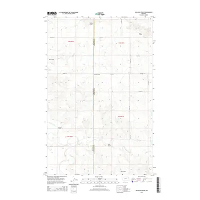
2014 Map of Sullivan Coulee
USGS Topo · Published 2014About this map
The Redwater River and its seasonal drainage network define this expanse of the eastern Montana plains along the border of McCone and Richland counties. The landscape is carved by prominent natural depressions such as Sullivan Coulee, Milne Coulee, and Hubbard Coulee, which serve as the primary topographic markers in an area otherwise characterized by high-plateau cattle country and dry-land farming. A sense of early settlement persists through labels like Grandview Cem, located on a high point near the junction of Co Road 142 and Co Road 305. The township and range lines of the Public Land Survey System organize the territory into a neat grid, with secondary routes like MT-201 and Sunnyside Rd providing the only modern infrastructure through the drainages of Muskrat Cr and E Redwater Cr.
Find a feature on this map
23 named features on this map. Tap any name to fly to it.
Don’t see what you’re looking for? This feature index may not catch every label — zoom into the map to look around manually.
Map Details
Editions of this 2014 Sullivan Coulee Map
This is the sole edition of this map. No revisions or reprints were ever made.
Other maps of this area

1912 · Chelsea
USGS Topo · 1:62,500

1912 · Poplar
USGS Topo · 1:62,500

1954 · Glendive
USGS Topo · 1:250,000

1954 · Wolf Point
USGS Topo · 1:250,000

1957 · Glendive
USGS Topo · 1:250,000

1958 · Wolf Point
USGS Topo · 1:250,000

1958 · Glendive
USGS Topo · 1:250,000

1972 · Poplar
USGS Topo · 1:24,000
1972 · Nickwall
USGS Topo · 1:24,000
1972 · Sprole
USGS Topo · 1:24,000