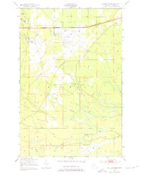
1951 Map of Sullivan Creek
USGS Topo · Published 1975About this map
Raco Field and its associated Rifle Range dominate the northern landscape of this portion of the Hiawatha National Forest during the early 1950s. The area is defined by a network of seasonal camps and recreational sites tucked into the timber, including the evocatively named Ol Misery Lodge, Camp Quiet, and the Black Creek Hunting Club. This survey captures a moment when the northern Michigan interior was transitioning between industrial utility and modern outdoor recreation, evidenced by the proximity of a Fish Hatchery and the Sullivan Creek Picnic Ground to active transportation lines.
Find a feature on this map
28 named features on this map. Tap any name to fly to it.
Don’t see what you’re looking for? This feature index may not catch every label — zoom into the map to look around manually.
Map Details
Editions of this 1951 Sullivan Creek Map
3 editions found
Other maps of this area

1941 · Strongs
USGS Topo · 1:63,360

1941 · Brimley
USGS Topo · 1:63,360

1951 · Strongs
USGS Topo · 1:24,000

1951 · McNearney Lake
USGS Topo · 1:24,000

1951 · Pendills Lake
USGS Topo · 1:24,000

1951 · Dollar Settlement
USGS Topo · 1:24,000

1951 · Sullivan Creek
USGS Topo · 1:24,000

1951 · Raco
USGS Topo · 1:24,000

1951 · Brimley
USGS Topo · 1:62,500

1951 · Strongs
USGS Topo · 1:62,500
Featured Places
- Trout Lake Township, MI
- Chippewa Township, MI
- Superior Township, MI
- Kinross Township, MI
- Chippewa County, MI