
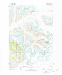
1961 Map of Sumdum A-2
USGS Topo · Published 1966About this map
Baird Glacier dominates this high-altitude landscape along the international boundary between Alaska and British Columbia. Surveyed in the early 1960s, the terrain is defined by massive ice fields and the deep crevasses of the Witches Cauldron. This portion of the Tongass National Forest showcases significant landmarks used for boundary demarcation, most notably the prominent Devils Thumb Boundary Peak 71 and the distinctive Cats Ears.
Find a feature on this map
14 named features on this map. Tap any name to fly to it.
Don’t see what you’re looking for? This feature index may not catch every label — zoom into the map to look around manually.
Map Details
Editions of this 1961 Sumdum A-2 Map
2 editions found
Other maps of this area

1952 · Petersburg
USGS Topo · 1:250,000

1952 · Sumdum
USGS Topo · 1:250,000

1960 · Petersburg
USGS Topo · 1:250,000

1960 · Sumdum A-1
USGS Topo · 1:63,360

1961 · Sumdum B-2
USGS Topo · 1:63,360

1961 · Petersburg D-3
USGS Topo · 1:63,360

1961 · Sumdum A-3
USGS Topo · 1:63,360

1961 · Petersburg D-1
USGS Topo · 1:63,360

1961 · Sumdum B-3
USGS Topo · 1:63,360

1961 · Petersburg D-2
USGS Topo · 1:63,360