
1961 Map of Sumdum B-2
USGS Topo · Published 1966About this map
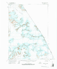
Dawes Glacier dominates the northern reaches of this high-altitude coastal range where the Canada-United States border cuts through the ice fields. This 1961 survey provides a detailed record of the glaciated terrain within the Tongass National Forest, illustrating the expansive ice sheets before decades of modern retreat. The map documents the high-relief topography of the Boundary Range, including Boundary Peak 74 and Boundary Peak 73, which serve as fixed points along the international boundary between Alaska and British Columbia. Other massive ice features like Oasis Glacier and Baird Glacier flow through the southern portion of the quadrangle, marked by numerous crevasses that indicate the active movement of these frozen rivers during the early 1960s. The lack of any roads or trails highlights the extreme isolation of this wilderness area at the time of the survey.
Find a feature on this map
9 named features on this map. Tap any name to fly to it.
Don’t see what you’re looking for? This feature index may not catch every label — zoom into the map to look around manually.
Map Details
Editions of this 1961 Sumdum B-2 Map
2 editions found
Other maps of this area

1952 · Sumdum
USGS Topo · 1:250,000

1960 · Sumdum A-1
USGS Topo · 1:63,360

1961 · Sumdum A-2
USGS Topo · 1:63,360

1961 · Sumdum C-3
USGS Topo · 1:63,360

1961 · Sumdum A-3
USGS Topo · 1:63,360
1961 · Sumdum C-2
USGS Topo · 1:63,360

1961 · Sumdum B-3
USGS Topo · 1:63,360

1961 · Sumdum
USGS Topo · 1:250,000

1996 · Sumdum B-3
USGS Topo · 1:63,360

2000 · Sumdum C-3
USGS Topo · 1:63,360