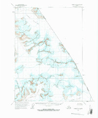
1961 Map of Sumdum B-2
USGS Topo · Published 1983About this map
Dawes Glacier dominates the northern reaches of this coastal Alaskan landscape, where the ice meets the international border between Alaska and British Columbia. Mapped in 1961, the region is characterized by an extensive network of ice fields and glaciers, including the sprawling Oasis Glacier and the northern edge of Baird Glacier. These massive ice bodies are punctuated by numerous crevasses, illustrating the active and shifting nature of the terrain within the Tongass National Forest. High-altitude markers such as Boundary Peak 74 and Boundary Peak 73 define the jagged eastern limit of the United States. This survey captures a frozen wilderness devoid of permanent roads or settlements, where the topographic focus is squarely on the intricate contouring of the peaks and the vast flow of the glacial systems as they appeared in the early 1960s.
Find a feature on this map
9 named features on this map. Tap any name to fly to it.
Don’t see what you’re looking for? This feature index may not catch every label — zoom into the map to look around manually.
Map Details
Editions of this 1961 Sumdum B-2 Map
2 editions found
Other maps of this area

1952 · Sumdum
USGS Topo · 1:250,000

1960 · Sumdum A-1
USGS Topo · 1:63,360

1961 · Sumdum A-2
USGS Topo · 1:63,360

1961 · Sumdum C-3
USGS Topo · 1:63,360

1961 · Sumdum B-2
USGS Topo · 1:63,360

1961 · Sumdum A-3
USGS Topo · 1:63,360
1961 · Sumdum C-2
USGS Topo · 1:63,360

1961 · Sumdum B-3
USGS Topo · 1:63,360

1961 · Sumdum
USGS Topo · 1:250,000

1996 · Sumdum B-3
USGS Topo · 1:63,360