
1961 Map of Sumdum C-3
USGS Topo · Published 1966About this map
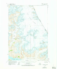
Dawes Glacier and South Sawyer Glacier dominate this 1961 aerial survey of the boundary between Alaska and British Columbia. The map captures a landscape defined by massive ice flows and glacial advancement or retreat within the Tongass National Forest. To the west, the ice flows toward Endicott Arm, while smaller features like Brown Glacier carve through the high terrain. The international border is clearly marked by fixed points such as Boundary Peak 70, showcasing the remote surveying efforts of the era. This document is a primary record of the glacial extent and topographic state of the region before modern climate shifts, providing an essential reference for environmental historians and cartographic collectors focusing on the Alaskan panhandle.
Find a feature on this map
9 named features on this map. Tap any name to fly to it.
Don’t see what you’re looking for? This feature index may not catch every label — zoom into the map to look around manually.
Map Details
Editions of this 1961 Sumdum C-3 Map
2 editions found
Other maps of this area

1943 · Sumdum B-4
USGS Topo · 1:63,360

1948 · Sumdum B-4
USGS Topo · 1:63,360

1952 · Sumdum
USGS Topo · 1:250,000

1960 · Sumdum D-4
USGS Topo · 1:63,360

1961 · Sumdum D-3
USGS Topo · 1:63,360

1961 · Sumdum B-2
USGS Topo · 1:63,360

1961 · Sumdum C-4
USGS Topo · 1:63,360
1961 · Sumdum C-2
USGS Topo · 1:63,360

1961 · Sumdum B-3
USGS Topo · 1:63,360

1961 · Sumdum
USGS Topo · 1:250,000