
1961 Map of Sumdum C-4
USGS Topo · Published 1966About this map
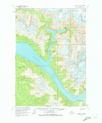
Fords Terror and the expansive glacial waters of Endicott Arm dominate this mid-century survey of the Tongass National Forest. The map documents a landscape defined by dramatic geological transitions, from the Brown Glacier and its associated crevasses in the northeast to the low-lying Tidal Flats along the shorelines. While the region is largely a wilderness of steep contours and complex waterways, evidence of resource extraction and seasonal habitation appears in the form of a Placer Mine near Placer Lakes and a solitary Cabin on the western shore of the arm. The drainage patterns of Chuck River and Sylvia Creek provide a detailed look at the hydraulic connections between the alpine interior and the saltwater inlets during the early 1960s.
Find a feature on this map
11 named features on this map. Tap any name to fly to it.
Don’t see what you’re looking for? This feature index may not catch every label — zoom into the map to look around manually.
Map Details
Editions of this 1961 Sumdum C-4 Map
2 editions found
Other maps of this area

1943 · Sumdum B-4
USGS Topo · 1:63,360

1948 · Sumdum C-5
USGS Topo · 1:63,360

1948 · Sumdum B-5
USGS Topo · 1:63,360

1948 · Sumdum D-5
USGS Topo · 1:63,360

1948 · Sumdum B-4
USGS Topo · 1:63,360

1951 · Sumdum C-5
USGS Topo · 1:63,360

1951 · Sumdum B-5
USGS Topo · 1:63,360

1952 · Sumdum
USGS Topo · 1:250,000

1955 · Sumdum D-5
USGS Topo · 1:63,360

1960 · Sumdum D-4
USGS Topo · 1:63,360