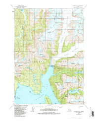
1961 Map of Sumdum A-3
USGS Topo · Published 1985About this map
The glacial landscape of the Tongass National Forest is defined here by the massive Baird Glacier, which dominates the northern reaches of this coastal Alaskan region. Flowing toward the waters of Thomas Bay, the terrain is carved by significant drainages including the Farragut River and Cascade Creek. This 1961 field-annotated survey, updated with 1970s hydrographic data, details the intricate shoreline where Ruth Island and Spray Island sit near the mouth of Scenery Cove. Peaks like Agassiz Peak and Dome Peak rise sharply from the water's edge, illustrating the dramatic elevation changes characteristic of the Cosmos Range. Interior lakes, such as Swan Lake and Scenery Lake, appear as isolated basins among the high ridges of Jenkins Peak and Fighting John Peak.
Find a feature on this map
42 named features on this map. Tap any name to fly to it.
Don’t see what you’re looking for? This feature index may not catch every label — zoom into the map to look around manually.
Map Details
Editions of this 1961 Sumdum A-3 Map

Other maps of this area

1943 · Sumdum B-4
USGS Topo · 1:63,360

1948 · Sumdum A-4
USGS Topo · 1:63,360

1948 · Sumdum B-4
USGS Topo · 1:63,360

1951 · Petersburg D-4
USGS Topo · 1:63,360

1951 · Sumdum A-4
USGS Topo · 1:63,360

1952 · Petersburg
USGS Topo · 1:250,000

1952 · Sumdum
USGS Topo · 1:250,000

1960 · Petersburg
USGS Topo · 1:250,000

1961 · Sumdum A-2
USGS Topo · 1:63,360

1961 · Sumdum B-2
USGS Topo · 1:63,360