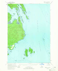
1948 Map of Sumdum B-6
USGS Topo · Published 1965About this map
Admiralty Island dominates this mid-century survey, showcasing a rugged coastline defined by protected inlets and navigational aids within the Tongass National Forest. The geography is centered on the intricate waters of Gambier Bay and Pybus Bay, where small settlements and camps like Pybus and Snug Cove are tucked into the shoreline. Navigational markers such as the Gambier Bay Entrance Light point to the area's importance for maritime traffic through Stephens Passage and Frederick Sound.
Find a feature on this map
32 named features on this map. Tap any name to fly to it.
Don’t see what you’re looking for? This feature index may not catch every label — zoom into the map to look around manually.
Map Details
Editions of this 1948 Sumdum B-6 Map
2 editions found
Other maps of this area

1948 · Sitka B-1
USGS Topo · 1:63,360

1948 · Sitka C-1
USGS Topo · 1:63,360

1948 · Sumdum A-5
USGS Topo · 1:63,360

1948 · Sumdum C-5
USGS Topo · 1:63,360

1948 · Sumdum A-6
USGS Topo · 1:63,360

1948 · Sumdum B-6
USGS Topo · 1:63,360

1948 · Sumdum C-6
USGS Topo · 1:63,360

1948 · Sumdum B-5
USGS Topo · 1:63,360

1948 · Sitka A-1
USGS Topo · 1:63,360

1951 · Sitka
USGS Topo · 1:250,000