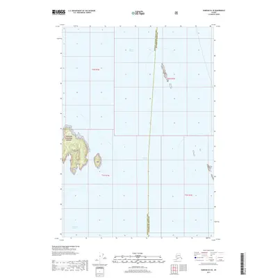
2017 Map of Sumdum B-6 SE
USGS Topo · Published 2017About this map
Stephens Passage and Frederick Sound define this coastal maritime landscape, where the cold waters of Southeast Alaska meet a series of prominent islands. Large portions of the landmass, including East Brother Island, are protected within the Tongass National Forest, illustrating the remote and preserved nature of the Alexander Archipelago. The chart follows the administrative boundary between the Hoonah-Angoon Census Area and Petersburg Borough, which cuts through the open water east of Sail Island. Isolated landmarks such as The Five Fingers serve as critical navigation points for vessels transitioning between these major Alaskan waterways, reflecting a geography shaped by glaciation and an economy historically tied to the sea.
Find a feature on this map
12 named features on this map. Tap any name to fly to it.
Don’t see what you’re looking for? This feature index may not catch every label — zoom into the map to look around manually.
Map Details
Editions of this 2017 Sumdum B-6 SE Map
This is the sole edition of this map. No revisions or reprints were ever made.
Other maps of this area

1948 · Sumdum A-5
USGS Topo · 1:63,360

1948 · Sumdum A-6
USGS Topo · 1:63,360

1948 · Sumdum B-6
USGS Topo · 1:63,360

1948 · Sumdum B-5
USGS Topo · 1:63,360

1951 · Sumdum B-5
USGS Topo · 1:63,360

1952 · Sumdum
USGS Topo · 1:250,000

1961 · Sumdum
USGS Topo · 1:250,000
1994 · Sumdum A-6
USGS Topo · 1:63,360
1996 · Sumdum B-5
USGS Topo · 1:63,360
2017 · Sumdum B-5 NW
USGS Topo · 1:25,000