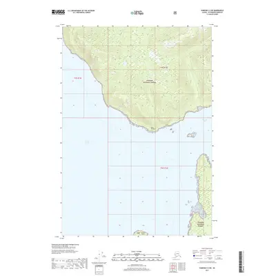
2017 Map of Sumdum C-5 SW
USGS Topo · Published 2017About this map
Tongass National Forest dominates this coastal Alaska landscape, where steep maritime slopes meet the waters of Stephens Passage. The topography is defined by sharp elevation changes rising directly from the shoreline, particularly around the prominent headland of Point Windham. To the south, Sunset Island sits just off the coast, marking the entrance to more protected waters near Windham Bay. This 2017 survey by the U.S. Geological Survey details a wilderness area where the absence of roads or permanent settlements reflects the remote nature of the Unorganized Borough. Mapping here focuses on the complex intersection of deep-water channels and high-relief coastal terrain typical of the Alexander Archipelago.
Find a feature on this map
8 named features on this map. Tap any name to fly to it.
Don’t see what you’re looking for? This feature index may not catch every label — zoom into the map to look around manually.
Map Details
Editions of this 2017 Sumdum C-5 SW Map
This is the sole edition of this map. No revisions or reprints were ever made.
Other maps of this area

1948 · Sumdum C-5
USGS Topo · 1:63,360

1948 · Sumdum B-6
USGS Topo · 1:63,360

1948 · Sumdum C-6
USGS Topo · 1:63,360

1948 · Sumdum B-5
USGS Topo · 1:63,360

1951 · Sumdum C-5
USGS Topo · 1:63,360

1951 · Sumdum B-5
USGS Topo · 1:63,360

1951 · Sumdum C-6
USGS Topo · 1:63,360

1952 · Sumdum
USGS Topo · 1:250,000

1961 · Sumdum
USGS Topo · 1:250,000
1996 · Sumdum B-5
USGS Topo · 1:63,360