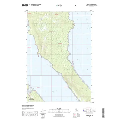
2017 Map of Sumdum C-6 NW
USGS Topo · Published 2017About this map
Glass Peninsula dominates this coastal survey, extending into the waters of Seymour Canal within the Tongass National Forest. The landscape is defined by its dramatic maritime topography, featuring high-elevation interior ridges such as The Stone Wall that rise sharply from the shoreline. Along the western coast, Sore Finger Cove and Pleasant Bay provide identifiable landmarks for maritime navigation and historical study. The absence of roads or developed settlements highlights the primitive state of this wilderness area, where the terrain is marked primarily by named points of interest like Midway Point. This map provides a detailed record of the peninsula's natural contours and coastline before the impacts of modern environmental shifts or future development.
Find a feature on this map
13 named features on this map. Tap any name to fly to it.
Don’t see what you’re looking for? This feature index may not catch every label — zoom into the map to look around manually.
Map Details
Editions of this 2017 Sumdum C-6 NW Map
This is the sole edition of this map. No revisions or reprints were ever made.
Other maps of this area

1948 · Sitka D-1
USGS Topo · 1:63,360

1948 · Sitka C-1
USGS Topo · 1:63,360

1948 · Sumdum D-6
USGS Topo · 1:63,360

1948 · Sumdum C-6
USGS Topo · 1:63,360

1951 · Sitka
USGS Topo · 1:250,000

1951 · Sitka D-1
USGS Topo · 1:63,360

1951 · Sumdum D-6
USGS Topo · 1:63,360

1951 · Sitka C-1
USGS Topo · 1:63,360

1951 · Sumdum C-6
USGS Topo · 1:63,360

1952 · Sumdum
USGS Topo · 1:250,000