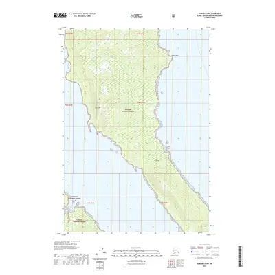
2021 Map of Sumdum C-6 NW
USGS Topo · Published 2021About this map
Glass Peninsula dominates this coastal survey, where the dense wilderness of the Tongass National Forest meets the tidal waters of Southeast Alaska. This portion of the Hoonah-Angoon Census Area highlights the intricate shoreline and steep topography characteristic of the Alexander Archipelago. Along the western edge, Sore Finger Cove and Pleasant Bay offer sheltered waters, while the prominent ridge known as The Stone Wall rises sharply from the forest floor. The map traces the eastern shoreline of the peninsula along Seymour Canal, extending to Midway Point. This 2021 edition provides an essential record of the natural landforms and federal boundaries defining this roadless maritime landscape, serving as a critical reference for understanding the geography of the Tongass before further ecological or climate shifts.
Find a feature on this map
13 named features on this map. Tap any name to fly to it.
Don’t see what you’re looking for? This feature index may not catch every label — zoom into the map to look around manually.
Map Details
Editions of this 2021 Sumdum C-6 NW Map
This is the sole edition of this map. No revisions or reprints were ever made.
Other maps of this area

1948 · Sitka D-1
USGS Topo · 1:63,360

1948 · Sitka C-1
USGS Topo · 1:63,360

1948 · Sumdum D-6
USGS Topo · 1:63,360

1948 · Sumdum C-6
USGS Topo · 1:63,360

1951 · Sitka
USGS Topo · 1:250,000

1951 · Sitka D-1
USGS Topo · 1:63,360

1951 · Sumdum D-6
USGS Topo · 1:63,360

1951 · Sitka C-1
USGS Topo · 1:63,360

1951 · Sumdum C-6
USGS Topo · 1:63,360

1952 · Sumdum
USGS Topo · 1:250,000