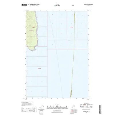
2017 Map of Sumdum C-6 SE
USGS Topo · Published 2017About this map
Tongass National Forest dominates the western coastline of this coastal Alaskan landscape, where the wooded terrain of Glass Peninsula terminates at Point Hugh. This 2017 survey documents the maritime boundary where the waters of Stephens Passage meet the shore, serving as a critical navigation point within the Alexander Archipelago. The map also delineates the administrative division between the Hoonah-Angoon Census Area and the Petersburg Borough, a line that runs north-to-south through the open water. This intersection of federal forest land and borough boundaries provides a precise look at the geography of the Inside Passage as it appeared in the early 21st century.
Find a feature on this map
7 named features on this map. Tap any name to fly to it.
Don’t see what you’re looking for? This feature index may not catch every label — zoom into the map to look around manually.
Map Details
Editions of this 2017 Sumdum C-6 SE Map
This is the sole edition of this map. No revisions or reprints were ever made.
Other maps of this area

1948 · Sumdum C-5
USGS Topo · 1:63,360

1948 · Sumdum B-6
USGS Topo · 1:63,360

1948 · Sumdum C-6
USGS Topo · 1:63,360

1948 · Sumdum B-5
USGS Topo · 1:63,360

1951 · Sumdum C-5
USGS Topo · 1:63,360

1951 · Sumdum B-5
USGS Topo · 1:63,360

1951 · Sumdum C-6
USGS Topo · 1:63,360

1952 · Sumdum
USGS Topo · 1:250,000

1961 · Sumdum
USGS Topo · 1:250,000
1996 · Sumdum B-5
USGS Topo · 1:63,360