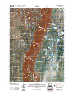
2011 Map of Summer Lake
USGS Topo · Published 2011About this map
The settlement of Summer Lake and its surrounding high-desert wetlands are mapped here in the early 21st century. This region of Lake County is defined by the significant management of water, visible through features like the Summer Lake I D Canal, Bullgate Dike, and the extensive Summer Lake Game Mgt Area. Local infrastructure is concentrated along the highway, including the Summer Lake Post Office and the Summer Lake Safety Rest Area, while the Summer Lake Cemetery serves as a vital point of reference for genealogists. The landscape rises sharply to the west toward Dead Indian Rim and Dead Indian Mountain, providing a stark contrast to the scattered water bodies of the basin such as Ana Reservoir, Dutchy Lake, and Jacks Lakes. The inclusion of the Ponderosa Paraglide Launch Area reflects modern recreational uses of these prominent ridges.
Find a feature on this map
26 named features on this map. Tap any name to fly to it.
Don’t see what you’re looking for? This feature index may not catch every label — zoom into the map to look around manually.
Map Details
Editions of this 2011 Summer Lake Map
This is the sole edition of this map. No revisions or reprints were ever made.
Other maps of this area

1955 · Crescent
USGS Topo · 1:250,000

1955 · Klamath Falls
USGS Topo · 1:250,000

1957 · Crescent
USGS Topo · 1:250,000

1958 · Crescent
USGS Topo · 1:250,000

1958 · Klamath Falls
USGS Topo · 1:250,000

1966 · Summer Lake
USGS Topo · 1:24,000

1966 · Fremont Point
USGS Topo · 1:24,000

1966 · Pole Butte
USGS Topo · 1:24,000

1966 · Foster Butte
USGS Topo · 1:24,000

1970 · Crescent
USGS Topo · 1:250,000