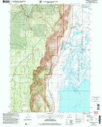
2004 Map of Summer Lake
USGS Topo · Published 2007About this map
Winter Ridge dominates the western half of this landscape, its steep eastern escarpment dropping sharply toward the basin of Summer Lake. This 2004 revision reveals a distinct geography of water management and conservation, where the Summer Lake State Wildlife Area manages the marshlands and lakes east of the ridge. The settlement of Summer Lake and the nearby Summer Lake Rest Area serve as small hubs along the Outback scenic route, reflecting the transition from the high-elevation timber of the Fremont National Forest to the arid alkali flats below. Local history is anchored by the Grange Hall and the Ana River Sch, while water sources like Ana Reservoir and Flowing Well remain critical infrastructure for this part of Lake County. Notable landmarks such as Dead Indian Mountain and Campbell Hill define the horizon, marking a territory where topography dictated early ranching and travel routes.
Find a feature on this map
25 named features on this map. Tap any name to fly to it.
Don’t see what you’re looking for? This feature index may not catch every label — zoom into the map to look around manually.
Map Details
Editions of this 2004 Summer Lake Map
This is the sole edition of this map. No revisions or reprints were ever made.
Other maps of this area

1955 · Crescent
USGS Topo · 1:250,000

1955 · Klamath Falls
USGS Topo · 1:250,000

1957 · Crescent
USGS Topo · 1:250,000

1958 · Crescent
USGS Topo · 1:250,000

1958 · Klamath Falls
USGS Topo · 1:250,000

1966 · Summer Lake
USGS Topo · 1:24,000

1966 · Fremont Point
USGS Topo · 1:24,000

1966 · Pole Butte
USGS Topo · 1:24,000

1966 · Foster Butte
USGS Topo · 1:24,000

1970 · Crescent
USGS Topo · 1:250,000