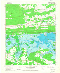
1965 Map of Summerfield
USGS Topo · Published 1967About this map
Lake Wister dominates the central landscape of this mid-1960s survey, its waters reaching into the surrounding timberlands of the Ouachita National Forest. The map captures the transition between the lowlands of the Poteau River and the rising elevations of Sulphur Spring Mtn and Goat Ridge. This period shows a well-established transportation network where the Chicago Rock Island and Pacific and the St Louis - San Francisco railroads intersect the terrain, providing a look at the industrial corridors that shaped Le Flore County. Local life is anchored in small communities like Summerfield and Victor, with family history markers found at the Summerfield Cem and Maxey Cem. The presence of an Old RR Grade and scattered sites like a Gas Well and the Community Chapel reflect the varied economic and social fabric of the valley during this era.
Find a feature on this map
37 named features on this map. Tap any name to fly to it.
Don’t see what you’re looking for? This feature index may not catch every label — zoom into the map to look around manually.
Map Details
Editions of this 1965 Summerfield Map
This is the sole edition of this map. No revisions or reprints were ever made.
Other maps of this area

1900 · Sallisaw
USGS Topo · 1:125,000

1900 · Winding Stair
USGS Topo · 1:125,000

1909 · Winding Stair
USGS Topo · 1:125,000

1911 · Sallisaw
USGS Topo · 1:125,000

1946 · Fort Smith
USGS Topo · 1:250,000

1950 · Mcalester
USGS Topo · 1:250,000

1959 · Heavener
USGS Topo · 1:62,500

1962 · McAlester
USGS Topo · 1:250,000

1965 · Fort Smith
USGS Topo · 1:250,000

1965 · McAlester
USGS Topo · 1:250,000