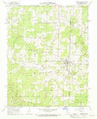
1968 Map of Summersville
USGS Topo · Published 1969About this map
Summersville sits at the heart of this late-1960s survey, straddling the high ground between the drainage of Spring Valley Creek and the Casto Valley Creek system. The map documents a rural Ozark landscape defined by long-established family and community landmarks, such as the Bethel Ch and several burial grounds including Riley Cem and Pickett Cem. The terrain is characterized by intricate hollows like Dirt House Hollow and Barnes Hollow, which contrast with the more open reaches of Bell Flats.
Find a feature on this map
22 named features on this map. Tap any name to fly to it.
Don’t see what you’re looking for? This feature index may not catch every label — zoom into the map to look around manually.
Map Details
Editions of this 1968 Summersville Map
2 editions found
Other maps of this area

1932 · Cedar Grove
USGS Topo · 1:48,000

1945 · Clear Springs
USGS Topo · 1:62,500

1946 · Summersville
USGS Topo · 1:62,500

1948 · Clear Springs
USGS Topo · 1:62,500

1948 · Summersville
USGS Topo · 1:62,500

1949 · Rolla
USGS Topo · 1:250,000

1951 · Raymondville
USGS Topo · 1:24,000
1951 · Lewis Hollow
USGS Topo · 1:24,000
1951 · Hartshorn
USGS Topo · 1:24,000

1951 · Raymondville
USGS Topo · 1:62,500