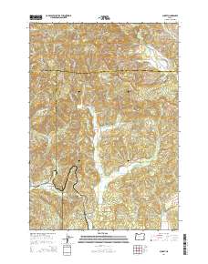
2014 Map of Summit
USGS Topo · Published 2014About this map
Summit and Nashville anchor this high-altitude landscape where the headwaters of several major drainages emerge from the Coast Range. The map illustrates a complex hydrographic divide, where the Yaquina River and its tributary, the Little Yaquina River, flow westward toward the Pacific, while the Luckiamute River and Marys River move eastward toward the Willamette Valley. This 2014 survey documents the persistence of small upland settlements and agricultural pockets like Happy Hollow, connected by a network of ridge-top and valley-floor roads including Summit Hwy and Bonner Ridge Rd. For genealogists and local historians, the sheet identifies several remote burial sites including Claremont Cem, May Stouts Cem, and Summit Cem. The terrain is defined by prominent peaks such as Green Mtn and Little Grass Mtn, which overlook the deep incision of Granite Canyon.
Find a feature on this map
68 named features on this map. Tap any name to fly to it.
Don’t see what you’re looking for? This feature index may not catch every label — zoom into the map to look around manually.
Map Details
Editions of this 2014 Summit Map
This is the sole edition of this map. No revisions or reprints were ever made.
Other maps of this area

1921 · Corvallis
USGS Topo · 1:62,500

1939 · Marys Peak
USGS Topo · 1:62,500

1942 · Marys Peak
USGS Topo · 1:62,500

1942 · Corvallis
USGS Topo · 1:62,500

1942 · Valsetz
USGS Topo · 1:62,500

1942 · Dallas
USGS Topo · 1:62,500

1953 · Salem
USGS Topo · 1:250,000

1954 · Salem
USGS Topo · 1:250,000
1956 · Corvallis
USGS Topo · 1:62,500

1956 · Valsetz
USGS Topo · 1:62,500