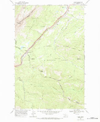
1968 Map of Summit
USGS Topo · Published 1984About this map
Marias Pass serves as the central crossing point where the Continental Divide meets the critical transportation corridor of the Burlington Northern railroad. This high mountain landscape is defined by the convergence of major public lands, including Glacier National Park, Lewis and Clark National Forest, and Flathead National Forest. The settlement at Summit anchors the pass, while the Theodore Roosevelt Pass highway winds through the terrain alongside Summit Creek.
Find a feature on this map
45 named features on this map. Tap any name to fly to it.
Don’t see what you’re looking for? This feature index may not catch every label — zoom into the map to look around manually.
Map Details
Editions of this 1968 Summit Map
This is the sole edition of this map. No revisions or reprints were ever made.
Other maps of this area

1913 · Marias Pass
USGS Topo · 1:125,000

1958 · Red Plume Mountain
USGS Topo · 1:24,000

1958 · Crescent Cliff
USGS Topo · 1:24,000

1958 · Mount Bradley
USGS Topo · 1:24,000

1960 · Cut Bank
USGS Topo · 1:250,000

1963 · Cut Bank
USGS Topo · 1:250,000

1964 · Cut Bank
USGS Topo · 1:250,000
1968 · Blacktail
USGS Topo · 1:24,000
1968 · Mount Rockwell
USGS Topo · 1:24,000
1968 · East Glacier Park
USGS Topo · 1:24,000