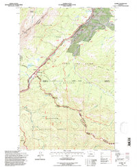
1995 Map of Summit
USGS Topo · Published 1997About this map
Marias Pass serves as the central focal point of this 1990s-era mountain survey, marking a significant breach in the Continental Divide where the Burlington Northern railroad and the Theodore Roosevelt Pass highway traverse the high terrain. The small settlement of Summit is positioned at this critical junction, representing the high point of the transcontinental rail line through the northern Rockies. The landscape is a complex intersection of administrative and natural boundaries, where Glacier National Park meets the Lewis and Clark National Forest and Flathead National Forest. To the south, the Great Bear Wilderness protects the headwaters of Bear Creek and Skyland Creek, while the north is defined by the peaks of Skeleton Mountain and Summit Mountain. This map documents a landscape defined by its role as a transportation corridor and a rugged wilderness buffer between Montana's famous national park and adjacent forest lands.
Find a feature on this map
69 named features on this map. Tap any name to fly to it.
Don’t see what you’re looking for? This feature index may not catch every label — zoom into the map to look around manually.
Map Details
Editions of this 1995 Summit Map
This is the sole edition of this map. No revisions or reprints were ever made.
Other maps of this area

1913 · Marias Pass
USGS Topo · 1:125,000

1958 · Red Plume Mountain
USGS Topo · 1:24,000

1958 · Crescent Cliff
USGS Topo · 1:24,000

1958 · Mount Bradley
USGS Topo · 1:24,000

1960 · Cut Bank
USGS Topo · 1:250,000

1963 · Cut Bank
USGS Topo · 1:250,000

1964 · Cut Bank
USGS Topo · 1:250,000
1968 · Blacktail
USGS Topo · 1:24,000
1968 · Mount Rockwell
USGS Topo · 1:24,000
1968 · East Glacier Park
USGS Topo · 1:24,000