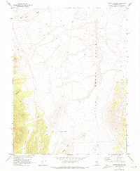
1968 Map of Summit Station
USGS Topo · Published 1973About this map
Little Smoky Valley dominates this high-altitude landscape of central Nevada, where the drainage of Big Wash and the contours of Andesite Ridge define the desert terrain. This 1968 field survey, conducted in cooperation with the Atomic Energy Commission, captures the remote character of the border between Nevada and Nye counties during a period of significant geological and nuclear-related research in the region. The map highlights the historical footprint of Summit Station (Site), a former stop in an area once vital for trans-Nevada travel. Steep elevations rise from the valley floor toward the west, carved by features like Twin Piñon Gulch. The scarcity of named settlements underscores the isolated nature of this high-desert basin during the late 1960s.
Find a feature on this map
5 named features on this map. Tap any name to fly to it.
Don’t see what you’re looking for? This feature index may not catch every label — zoom into the map to look around manually.
Map Details
Editions of this 1968 Summit Station Map
This is the sole edition of this map. No revisions or reprints were ever made.
Other maps of this area

1926 · Roberts Mountains
USGS Topo · 1:250,000

1929 · Roberts Mountains
USGS Topo · 1:250,000

1955 · Millett
USGS Topo · 1:250,000

1956 · Cockalorum Wash
USGS Topo · 1:62,500

1956 · Lund
USGS Topo · 1:250,000

1956 · Ely
USGS Topo · 1:250,000

1956 · Tonopah
USGS Topo · 1:250,000

1959 · Ely
USGS Topo · 1:250,000

1959 · Tonopah
USGS Topo · 1:250,000

1959 · Millett
USGS Topo · 1:250,000