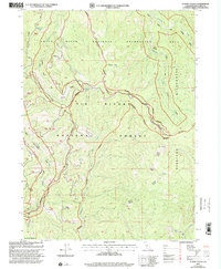
1997 Map of Summit Valley
USGS Topo · Published 2001About this map
Six Rivers National Forest and the Siskiyou Wilderness dominate this high-country survey of Del Norte County. The landscape is defined by the convergence of the Smith River corridor and its protected surroundings, with the Summit Valley Wilderness Boundary carving through the center of the sheet. Notable landmarks include the Summit Valley Lookout (Site) and geological features like Doctor Rock and South Red Mountain. Water sources are critical identifiers across this terrain, marked by several named points such as Woolly Bear Spring, Cedar Camp Spring, and Shelter Spring. This revision reflects the forest management priorities of the late 1990s, where the network of drainage systems like Blue Creek and Goose Creek are mapped alongside a single industrial Quarry in the southwest, illustrating the balance between natural resource protection and localized extraction.
Find a feature on this map
27 named features on this map. Tap any name to fly to it.
Don’t see what you’re looking for? This feature index may not catch every label — zoom into the map to look around manually.
Map Details
Editions of this 1997 Summit Valley Map
This is the sole edition of this map. No revisions or reprints were ever made.
Other maps of this area

1922 · Preston Peak
USGS Topo · 1:125,000

1925 · Hoopa
USGS Topo · 1:125,000

1945 · Ship Mountain
USGS Topo · 1:62,500

1945 · Tectah Creek
USGS Topo · 1:62,500

1948 · Weed
USGS Topo · 1:250,000

1950 · Weed
USGS Topo · 1:250,000

1952 · Ship Mountain
USGS Topo · 1:62,500

1952 · Orleans
USGS Topo · 1:62,500

1952 · Tectah Creek
USGS Topo · 1:62,500

1955 · Dillon Mtn
USGS Topo · 1:62,500