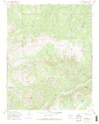
1967 Map of Summitville
USGS Topo · Published 1974About this map
Summitville sits high in the Rio Grande National Forest, defined by a legacy of underground exploration evident in the numerous mines and named tunnels that punctuate the mountain slopes. The landscape is a complex network of high peaks and deep drainages, where the Wightman Fork and Cropsy Creek flow beneath the towering heights of South Mountain and Cropsy Mountain. This 1967 field-checked survey reveals the industrial footprint of the era, from the Chandler Tunnel to the Iowa Tunnel, alongside remote seasonal outposts like Hutchison Corral. The southern portion of the sheet follows the course of the Alamosa River past Stunner Cabin, showing a region where high-altitude mining operations and public forest lands intersect. Geologists and local historians can trace the intricate jeep trails and a pipeline that serviced these remote operations across the continental divide country.
Find a feature on this map
54 named features on this map. Tap any name to fly to it.
Don’t see what you’re looking for? This feature index may not catch every label — zoom into the map to look around manually.
Map Details
Editions of this 1967 Summitville Map
4 editions found
Other maps of this area

1913 · Summitville
USGS Topo · 1:125,000

1914 · Creede
USGS Topo · 1:125,000

1915 · Summitville
USGS Topo · 1:125,000

1915 · Del Norte
USGS Topo · 1:125,000

1916 · Creede
USGS Topo · 1:125,000

1917 · Del Norte
USGS Topo · 1:125,000

1922 · Conejos
USGS Topo · 1:125,000

1945 · Durango
USGS Topo · 1:250,000

1953 · Durango
USGS Topo · 1:250,000

1954 · Durango
USGS Topo · 1:250,000