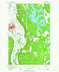
1956 Map of Sumner
USGS Topo · Published 1963About this map
White River and Puyallup River waters dominate this mid-century look at Pierce County, where the industrial and agricultural character of the valley is clearly defined. The White River Power Plant at Dieringer stands as a primary landmark, connected by a distinct tunnel and pipeline system to the expansive waters of Lake Tapps. The landscape is a complex network of moving water and infrastructure, including the Printz Basin and the winding course of Fennel Creek leading toward Victor Falls.
Find a feature on this map
50 named features on this map. Tap any name to fly to it.
Don’t see what you’re looking for? This feature index may not catch every label — zoom into the map to look around manually.
Map Details
Editions of this 1956 Sumner Map
4 editions found
Other maps of this area

1897 · Tacoma
USGS Topo · 1:125,000

1900 · Tacoma
USGS Topo · 1:125,000

1941 · Tacoma South
USGS Topo · 1:62,500

1942 · Lake Tapps
USGS Topo · 1:62,500

1944 · Lake Tapps
USGS Topo · 1:62,500

1944 · Tacoma South
USGS Topo · 1:62,500

1949 · Black Diamond
USGS Topo · 1:24,000

1949 · Poverty Bay
USGS Topo · 1:24,000

1949 · Auburn
USGS Topo · 1:24,000

1956 · Orting
USGS Topo · 1:24,000