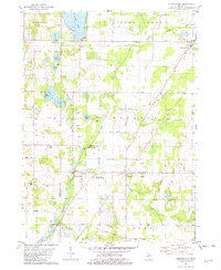
1981 Map of Sumnerville
USGS Topo · Published 1982About this map
Sumnerville and Pokagon anchor this 1980s landscape at the boundary of Berrien and Cass Counties, where the Dowagiac River and Dowagiac Creek converge. The topography reveals a transition between active transportation corridors and agricultural quiet, with the Amtrak line running parallel to an Old Railroad Grade. This mix of eras is evident in the proximity of established spiritual and memorial sites, such as Franklin Ch, Morris Chapel, and the expansive Mission Hills Memorial Gardens. To the north, the water-rich terrain around Indian Lake and Rodgers Lake gives way to industrial and civic infrastructure, including the County Memorial Airport and various Gravel Pits. The map documents a rural Michigan community maintaining its traditional settlement patterns while accommodating modern utility, from the Substation in the south to the Sewage Disposal facilities near the northern municipal borders.
Find a feature on this map
55 named features on this map. Tap any name to fly to it.
Don’t see what you’re looking for? This feature index may not catch every label — zoom into the map to look around manually.
Map Details
Editions of this 1981 Sumnerville Map
This is the sole edition of this map. No revisions or reprints were ever made.
Other maps of this area

1927 · Niles
USGS Topo · 1:62,500

1927 · Hartford
USGS Topo · 1:62,500

1927 · Benton Harbor
USGS Topo · 1:62,500

1930 · Benton Harbor
USGS Topo · 1:62,500

1930 · Niles
USGS Topo · 1:62,500

1931 · Hartford
USGS Topo · 1:62,500

1943 · Niles
USGS Topo · 1:62,500

1945 · Cassopolis
USGS Topo · 1:62,500

1947 · Cassopolis
USGS Topo · 1:62,500

1953 · Chicago
USGS Topo · 1:250,000