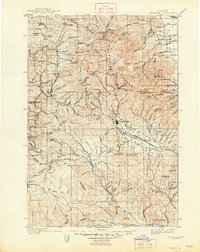
1901 Map of Sumpter
USGS Topo · Published 1948About this map
Sumpter serves as the focal point of this Eastern Oregon survey, capturing the region during a period of significant mining and railroad expansion. The narrow-gauge Sumpter Valley River R. R. winds through the topography, connecting timber and mineral interests between the Blue Mountains and the Powder River valley. This transportation network was critical for operations like the French Diggings and the Redboy and Baisley-Elkhorn mines, which were established deep in the high-elevation terrain of Elkhorn Ridge.
Find a feature on this map
132 named features on this map. Tap any name to fly to it.
Don’t see what you’re looking for? This feature index may not catch every label — zoom into the map to look around manually.
Map Details
Editions of this 1901 Sumpter Map
4 editions found
Other maps of this area

1901 · Baker City
USGS Topo · 1:125,000

1901 · Sumpter
USGS Topo · 1:125,000

1906 · Telocaset
USGS Topo · 1:125,000

1908 · Ironside Mountain
USGS Topo · 1:125,000

1951 · Bates
USGS Topo · 1:62,500

1951 · Desolation Butte
USGS Topo · 1:62,500

1953 · Pendleton
USGS Topo · 1:250,000

1955 · Baker
USGS Topo · 1:250,000

1955 · Grangeville
USGS Topo · 1:250,000

1955 · Canyon City
USGS Topo · 1:250,000