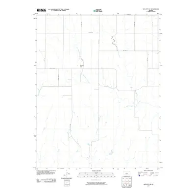
2009 Map of Sun City NE
USGS Topo · Published 2009About this map
South Elm Creek and its complex network of tributaries define this rural landscape in Pratt County. The terrain is marked by the convergence of the West Branch South Elm Creek and East Branch South Elm Creek, which join to form the main channel. A significant local landmark, the MacAdoo Dam, is situated along the West Branch, indicating water management or agricultural priorities for the area's residents. The road system is dominated by a grid of numbered and named routes, such as Coats Rd and McAdoo Rd, which navigate the various drainage basins. In the western portion of the sheet, the headwaters of Mulberry Creek begin to carve through the landscape, while Cottonwood Creek flows through the southern reaches, highlighting the region's reliance on these vital waterways.
Find a feature on this map
22 named features on this map. Tap any name to fly to it.
Don’t see what you’re looking for? This feature index may not catch every label — zoom into the map to look around manually.
Map Details
Editions of this 2009 Sun City NE Map
This is the sole edition of this map. No revisions or reprints were ever made.
Other maps of this area

1891 · Medicine Lodge
USGS Topo · 1:125,000

1892 · Pratt
USGS Topo · 1:125,000

1893 · Medicine Lodge
USGS Topo · 1:125,000

1894 · Pratt
USGS Topo · 1:125,000

1955 · Pratt
USGS Topo · 1:250,000

1959 · Pratt
USGS Topo · 1:250,000

1968 · Sun City SW
USGS Topo · 1:24,000

1968 · Pratt SW
USGS Topo · 1:24,000
1968 · Sun City
USGS Topo · 1:24,000

1968 · Coats
USGS Topo · 1:24,000