1976 Map of Sun NE
USGS Topo · Published 1977About this map
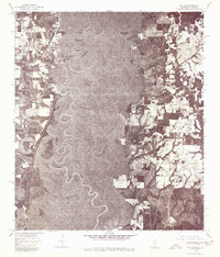
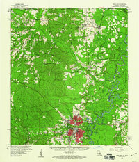
The Pearl River snakes in tight, complex oxbows through the center of this 1976 orthophotoquad, defining a heavily forested corridor along the Mississippi and Louisiana border. This aerial perspective, prepared from 1976 photography, reveals the stark contrast between the dense vegetation of the river bottomlands and the cleared agricultural plots and timber tracts on the higher ground. Unlike a traditional topographic map, this imagery provides a direct view of the land surface as it appeared in the mid-1970s, showing the precise footprints of rural homesteads and the network of logging roads and local lanes. The small settlement of Henleyfield sits on the eastern side of the river, while the area around Lees Creek anchors the northwestern portion of the sheet. The image preserves the specific clearing patterns and riparian morphology of the river valley before later development or natural shifts altered the channel.
Find a feature on this map
3 named features on this map. Tap any name to fly to it.
Don’t see what you’re looking for? This feature index may not catch every label — zoom into the map to look around manually.
Map Details
Editions of this 1976 Sun NE Map
This is the sole edition of this map. No revisions or reprints were ever made.
Other maps of this area

1942 · Talisheek
USGS Topo · 1:31,680
1942 · Rio
USGS Topo · 1:31,680

1942 · Walkiah Bluff
USGS Topo · 1:31,680

1942 · Pools Bluff
USGS Topo · 1:31,680
1949 · Bogalusa East
USGS Topo · 1:31,680
1949 · Bogalusa West
USGS Topo · 1:31,680

1953 · Mobile
USGS Topo · 1:250,000

1957 · Mobile
USGS Topo · 1:250,000

1958 · Picayune
USGS Topo · 1:62,500
1959 · Bogalusa
USGS Topo · 1:62,500