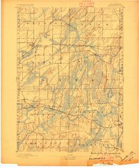
1890 Map of Sun Prairie
USGS Topo · Published 1896About this map
Sun Prairie serves as a primary hub in this late nineteenth-century portrait of eastern Dane County, where the landscape is defined by the repetitive, elongated ridges typical of the region's glacial topography. Two major rail corridors anchor the local economy and settlement patterns: the Chicago Milwaukee and St Paul Railroad crossing the northern townships through Deansville and Marshall, and the Chicago and Northwestern Railroad further south.
Find a feature on this map
32 named features on this map. Tap any name to fly to it.
Don’t see what you’re looking for? This feature index may not catch every label — zoom into the map to look around manually.
Map Details
Editions of this 1890 Sun Prairie Map
2 editions found
Other maps of this area

1889 · Evansville
USGS Topo · 1:62,500

1890 · Madison
USGS Topo · 1:62,500

1890 · Sun Prairie
USGS Topo · 1:62,500

1890 · Stoughton
USGS Topo · 1:62,500

1891 · Waterloo
USGS Topo · 1:62,500

1891 · Koshkonong
USGS Topo · 1:62,500

1892 · Madison
USGS Topo · 1:62,500

1894 · Waterloo
USGS Topo · 1:62,500

1894 · Evansville
USGS Topo · 1:62,500

1894 · Koshkonong
USGS Topo · 1:62,500