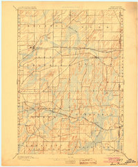
1896 Map of Sun Prairie
USGS Topo · Published 1904About this map
Sun Prairie and the surrounding townships of eastern Dane County are depicted during a period of significant agricultural and railroad expansion. The landscape is defined by its glacial topography, with numerous drumlins and marshlands drained by Koshkonong Creek and Waterloo Creek. The development of the region is closely tied to the iron rail, with the Chicago Milwaukee and St Paul Railroad and the Chicago and Northwestern Railroad carving paths through the prairie to serve rural hubs. Small settlements like Deansville, London, and Cottage Grove appear as vital local junctions for the farming community. Genealogists may find interest in the documented locations of several smaller localities such as Adsit, Hope, and Nora, which provide a detailed look at the nineteenth-century settlement pattern before the automotive age reshaped the county.
Find a feature on this map
40 named features on this map. Tap any name to fly to it.
Don’t see what you’re looking for? This feature index may not catch every label — zoom into the map to look around manually.
Map Details
Editions of this 1896 Sun Prairie Map
2 editions found

Other maps of this area

1889 · Evansville
USGS Topo · 1:62,500

1890 · Madison
USGS Topo · 1:62,500

1890 · Sun Prairie
USGS Topo · 1:62,500

1890 · Stoughton
USGS Topo · 1:62,500

1891 · Waterloo
USGS Topo · 1:62,500

1891 · Koshkonong
USGS Topo · 1:62,500

1892 · Madison
USGS Topo · 1:62,500

1894 · Waterloo
USGS Topo · 1:62,500

1894 · Evansville
USGS Topo · 1:62,500

1894 · Koshkonong
USGS Topo · 1:62,500